Water Resources
Objective:
- Capturing precise coordinates (X, Y and Z) of all the Observation Wells being maintained by GWD by conducting DGPS survey.
- Creation of Digital Elevation Model (DEM) of water levels of observation wells.
Description:
Geo-referenced all the ground water observation wells by capturing precise coordinates (X, Y and Z) being maintained by Groundwater Department (GWD), create geospatial database in digital environment which will help monitor the ground water levels in the state as part of National Hydrology Project.
- Rajiv Gandhi National Drinking Water Mission (RGNDWM), Ministry of Drinking Water & Sanitation, Govt. of India.
- Preparation of ground water quality layer on 1:50,000 scale and mapping the status of ground water quality with respect to its suitability for human consumption at a given point of time.
Output:
- Element wise and integrated ground water quality maps showing spatial and temporal distribution for 9 elements depicting suitability for human consumption.
- DSS for recharge or to take alternate drinking water source
- Regional / State Ground water quality map
- Ground water quality map corresponding to SoI toposheet on 1:50,000 scale up to habitation level


Drinking water supply schemes may be managed sustainably by using the applications of RS & GIS technology. GIS helps in monitoring the status of habitations, for selecting site specific locations, studying regional water quality monitoring, to know up to date status of the water quality affected habitations and to alert the administration / local community for taking alternate remedial measures.
NRSC, Department of Space (DoS), Govt of India & Rajiv Gandhi National Drinking Water Mission (RGNDWM), Ministry of Drinking Water & Sanitation, Govt. of India
Objective:- Creation of seamless mosaic of 17 layers and Hydrogeomorphology maps on 1:50,000 Scale for entire Telangana state as per the guidelines of RGNDWM Phase-III.
Part of Telangana is covered under Phase-I of the project and the remaining part is covered in Phase-III. The guidelines were different for Phase-I to Phase-III. Under the Seamless Mosaic Project, all the maps pertaining to Telangana State generated are brought in to common format as adopted by RGNDWM Phase III i. e. LCC projection with WGS84 datum.
Output:- Grid wise and seamless mosaic of Hydrogeomorphology maps on 1:50,000 Scale for entire Telangana as per the guidelines of RGNDWM Phase-III.
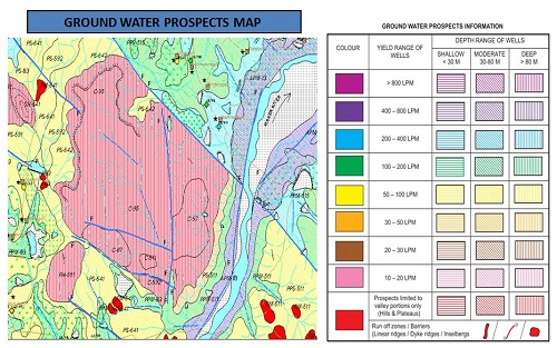
Groundwater is the main source of water for domestic, agriculture and industrial uses. Telangana Remote Sensing Applications Centre (TGRAC) in collaboration with National Remote Sensing Centre (NRSC/DoS) and sponsored by Ministry of Drinking Water & Sanitation, Govt. of India has prepared the Ground Water Prospects maps for the state of Telangana. The maps are prepared scientifically by using satellite remote sensing technology with limited field checks on 1: 50,000 scale. The maps show prospective zones for ground water occurrence and tentative locations for constructing recharge structures. The information provided in the ground water prospects maps form a suitable database for narrowing down the target zones and systematic selection of sites for drilling after conducting follow up ground surveys. This information can be utilized by hydrogeologists, Engineers and other private / NGO organizations for ground water development.
Spatially user can visualizes the Ground Water Prospects information in terms of depth (shallow, moderate and deep) shown with three colour hatching patterns (horizontal, inclined and vertical) and yield shown in seven colours (VIBGYOR - Violet, Indigo, Blue, Green, Yellow, Orange and Red) with simplified legend.
TGRAC is the nodal agency for Remote Sensing, GIS and related applications, registered under AP societies Registration Act, 2001 (779 of 2009) with Telangana Adaptation Order 2014. As per G. O. Ms. No. 28 & 29, Planning (I) Department, Dt. 05-08-2013, orders have been issued for establishment of Telangana (erstwhile Andhra Pradesh) Geo-graphic Management Information System (TSGMIS) & Telangana (erstwhile Andhra Pradesh) State Spatial Data Infrastructure (TSSDI). The TSGMIS is established with an objective of a new information regime supporting good governance, sustainable development and citizen empowerment through offering GIS decision support services; a state-wide, standardised, seamless and most-current GIS asset for governance, private enterprise and citizens. The TSSDI as state level repository of a digital “warehouse” of the state map data holdings (that include the satellite images, SoI maps and other GIS layers) and to facilitate the sharing and access of the digital spatial information for promoting remote sensing based planning and monitoring of activities at community, local and state levels for better governance.
As part of TSSDI & TSGMIS, Spatial Data Management Hub (SDMH) will be established in 14 selected departments and RWS&S is one of the departments identified. The Geosciences Division of TRAC has conducted half-a-day training programme to about 352 Engineers in 9 batches on "Fundamentals of Remote Sensing (RS) & GIS Application and usage of Ground water prospecting" during October 2013 to April 2014 as part of induction training programme to newly recruited RWS&S Engineers. The SDMH shall have the overall goal to improve the quality of life by enhancing access to better water supply & sanitation facilities in the rural areas and ensuring sustainability.
The remote sensing and GIS techniques have emerged as very effective and reliable tools in the groundwater studies. The Spatial Data Management Hub (SDMH) in RWS&S helps in sustainably managing the community based water supply schemes. GIS helps in monitoring the status of habitations, for selecting site specific locations for studying regional water quality monitoring, to know up to date status of the water quality affected habitations and to alert the administration / local community for taking alternate remedial measures.
Training content:- Concepts of SDMH & RWSS Functions
- Principles of Remote Sensing & GIS
- Preparation and Usage of Groundwater Prospects Maps
Engineering Staff College of India (ESCI) & TSIPARD(Telangana State Institute Of Panchayat Raj And Rural Development(erstwhile APARD) Hyderabad
Sponsored by Ministry of Irrigation, Government of Telangana.
It is an in-house project for I&CAD Department in continuation of Consistent monitoring of command areas under Major and Medium Irrigation Projects, from the last few years, TRAC has monitored, the seasonal cropping pattern of the command areas in both Kharif and Rabi seasons, using Remote Sensing techniques supplemented with field data. The result acquired from the study is of immense use to the Irrigation department for planning the water management activities under the command of each Irrigation Project.
Study Area :7 major and 34 medium irrigation projects of TS
Objective:
- Efficient water management at all levels of water distribution.
- Identification of agricultural productivity for assessment of resources, environment and the returns from investment.
Output:

Sponsored by National Bank of Agriculture and Rural Development (NABARD).
All the watersheds completed by NABARD in Telangana state needs monitoring for which NABARD wants to host the watershed data in NRSC Bhuvan portal. TRAC has completed 36 watersheds in Compliance with Bhuvan portal.
Sponsored by I & CAD, Government of Telangana.
Objective:- The specific objective of this project is identification of feasible sites for construction of new tanks over eight districts and information regarding physical status of tanks through hydrological analysis which reflects the possible ground water scenario over the corresponding districts and state as well.
- Drainage, catchment and tank cascades of the sub basins.
- Hydrological analysis of tanks and cascades including yield (runoff) using SCS curve method and analysis of master plan records data.
- Feasible sites for new tanks
- Analysis of Physical status of tanks
- Groundwater scenario
-
Reservoir sedimentation study is essential for estimating the sediment yield into the reservoir which influences the storage capacity of the reservoir/dam. The aim of this study is to assess reservoir sedimentation and/or loss of storage in five irrigation projects i.e, Sreeramsagar, Nizamsagar, Singur, Lower Maner dam, Kaddam in Godavari Basin in Andhra Pradesh through systematic analysis by using high resolution IRS-1C, 1D and P6, LISS-IV & LISS-III and microwave data.
- Mapping and estimation of water spread areas,
- Rate of loss in capacity due to sedimentation,
- Revised Level-Area-Capacity curves within the zone of interest i.e., live storage of the reservoir
- Field work for ground truth verification
-
The focus of this study is assessing the changes in waterscapes so as to facilitate effective management on issues related to water scarcity. This involves comprehensive analysis of Manair subbasin which would facilitate water saving strategies and to enhance agriculture productivity.
- Analysis of Manair subbasin with estimation of indicators on water resource, Evapotranspiration, Productivity and withdrawals for water accounting.
- To study external and internal catchments and its influence on the internal drainage system of RGIA
- To evolve a strategy with solutions to address the short term and long term drainage risks.
- Study of the external catchment areas and their influence on the hydrology of RGIA
- Study of the influence of internal catchment areas on the external drainage and suggest actions to avoid flood risk
- Analysis of reasons for the damages caused to the boundary walls and other areas
- Identification of vulnerable points of flood risk, along the boundary wall as well as other areas.
- Suggest schematic solutions for overcoming the drainage risks
In house project of TGRAC for Ministry of Panchayat Raj Dept, Government of Telangana.
TGRAC has extensively used Remote Sensing Satellite data and GIS techniques in preliminary planning of the project for entire state within a shortest period. The spatial network of the existing Rural Water Supply infrastructure is captured. Using Digital Elevation Model data the elevations of habitations that of surface water source were assessed, Habitations were either connected by gravity pipeline else through pumping pipeline to nearest hillock, from the source. About a total of 18,507 required structures were identified, about 4,430 Km of Main Grid, 44,466 Km of Sub-Grid and 38,506 Km of distribution network was analyzed and extracted. Based on the work of TRAC, estimations were prepared by RWS. Permissions were taken from railway department for identified crossing points of pipeline with Railway line and from the Forest department for the pipeline passing through the forest areas of about 910 acres.

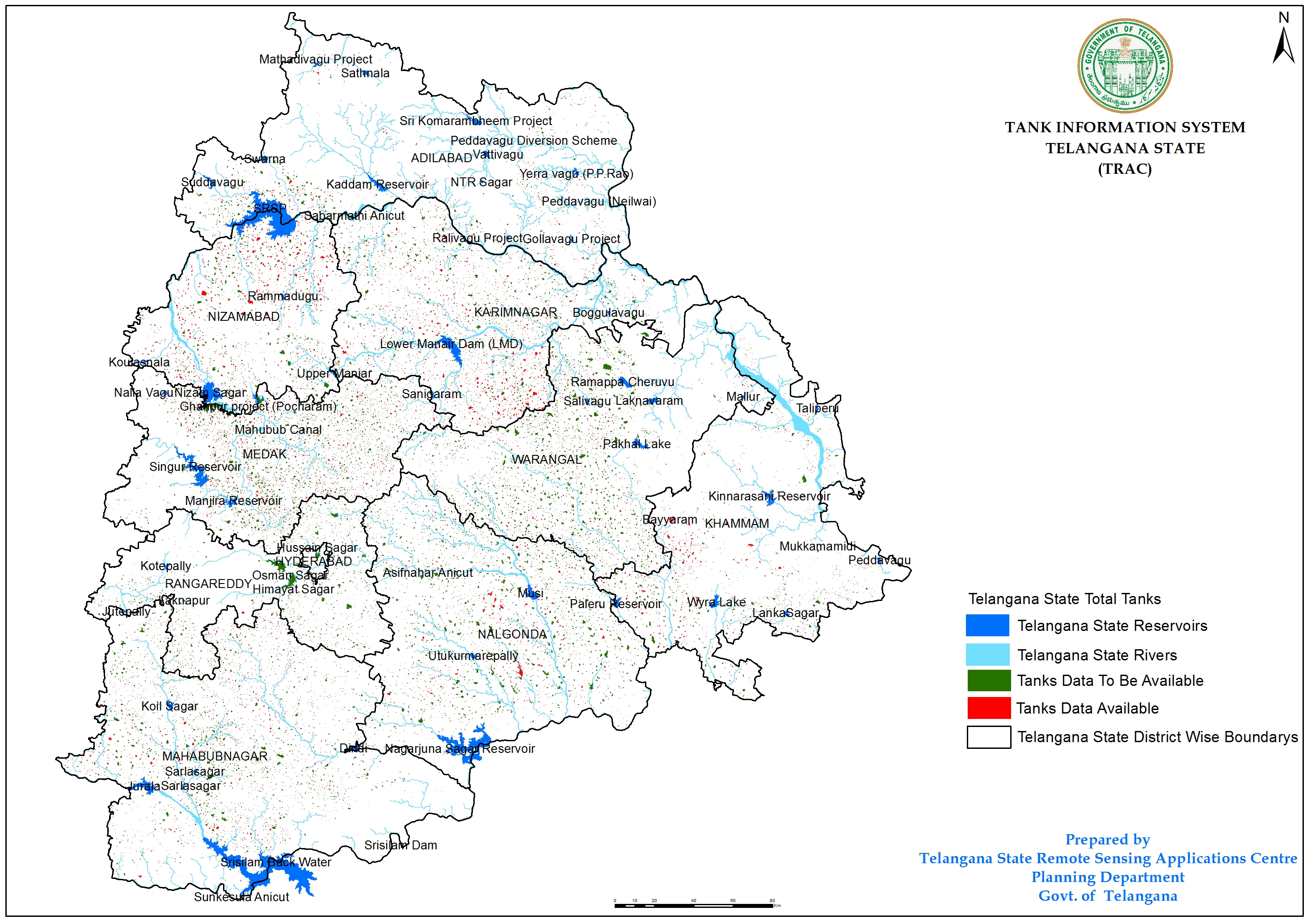
Objective
Development of web based Tank Information System for all tanks in Telangana Query and reporting facility through compilation of natural resources information related to all tanks of catchment and command areas
Output: