

Geomatics
Objectives:
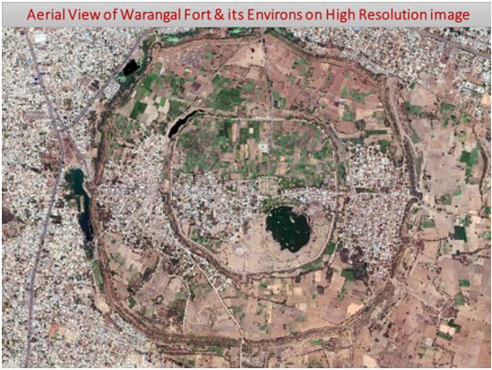
- Creation of digital database comprising of comprehensive archaeological information pertaining to the 4 Sectors - Northern, North Eastern, Western and North Western Sectors of the Mud-Wall of Warangal Fort.
- Identification of 4 Sectors - Northern, North Eastern, Western and North Western Sectors along the mud-wall of the Warangal Fort for exploration/excavation.
- Delineation of Structures / Monuments hidden in the 4 Sectors - Northern, North Eastern, Western and North Western Sectors of the Mud-Wall of Warangal Fort.
- Development of a dedicated Web based Archaeological Geographic Information System for the usage of Hyderabad Circle of ASI.
Objectives:
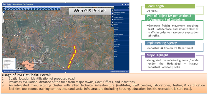
- Geo-referenced GIS infrastructure data layers with uniform quality and standards.
- Integration of the data layers in to the PM Gati Shakti Digital Platform and interact with BISAG-N in developing state master plan
- Establish and maintain a PM Gatishakti Data centre.
- To Create customized departmental tools for ease of retrieving the data uploaded on various layers
- Development of a application programme Interface for communicating between the state and central Govt., layers
- To build Infrastructure Geo Portal for the State of Telangana using geospatial databases to support needs of the state departments and to enable decision makers in planning.
- The geo spatial databases can be used for developing tools that will help government in making informed decisions on infrastructure development.
- Acquisition, and upload of spatial data for gap areas as and when necessary could be collected. Standardize existing spatial data available with different state departments by preparing detailed Metadata.
- The stored data improves the utilization of spatial data and forms as a gateway of spatial data generated by various departments / agencies.
- Strengthen the decentralized planning process in accordance.
- To enable an authorized user anywhere to access these servers and get the required query in a map format for getting NOCs.
Objectives:
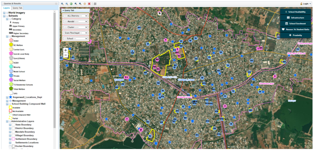
- Mapping of Schools with Gram Panchayats linkage.
- Geospatial Mapping of schools in cluster wise.
- Classification of Facility based locations
- Mapping of School premises as Polygon feature to assess the extent/area of the premises starting from HSS, HS, UPS and PS. This exercise will provide the extent/area of school premises, land availability for future development.
- Optimal Route maps for guiding material distributions.
- Planning for establishing new schools with accessibility of distance and enrollment potential
- Hosting of geospatial database base of schools in Web-GIS for visualization, querying and monitoring.
- Assisting for Development of new infrastructure based on analysis of existing infrastructure / facilities.
- Planning for establishing new schools with accessibility of distance and enrolment potential.
- GIS based analysis on Government school results can focus on
- poor performing schools, which can help officials to adopt effective measures.
- Query & analysis for location based departmental requirements.
- Decision making support system.
Objectives:
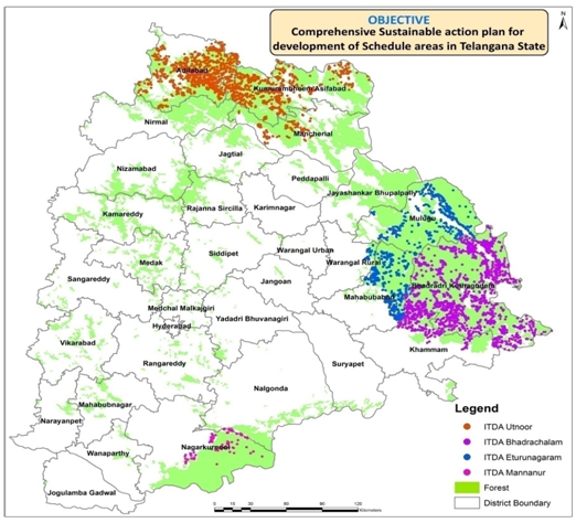
- Generation of sector-wise integrated resources maps of the schedule Areas.
- Geo-tagging of all capital assets in each and every habitation of schedule areas and tribal habitations in non schedule areas.
- Assist in preparation of perspective plans by using the asset and resource information.
- Generation of GIS Database (Base Layers)
- The basic layer wise GIS database includes, Tribal Administrative units including habitations, Updation of Transport Network, including thematic data such as Forest Cover, Topography and Surface Water bodies would be generated.
- Development of Mobile Application – A Mobile Application for the 5 categories of assets (Education/Health/GCC Godowns & DR Depots/Govt. Institutions/Community Halls)
- Development of Web-GIS application - with retrieval, updation and querying tools. Decision support system with analysis tools such as Gaps, Site Suitability and Proximity. Data Processing & Analysis : need based analysis to identify the gaps, site suitability and proximity analysis with respect to prioritized capital assets.
Objectives:
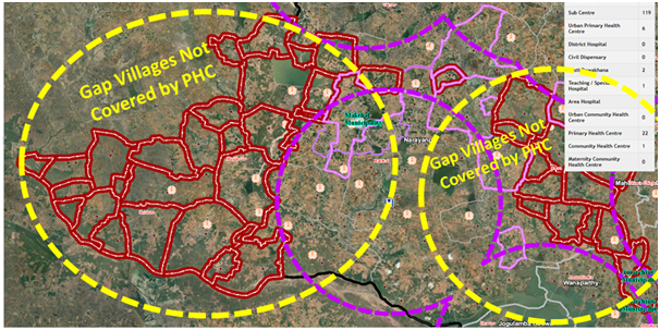
- Digital mapping of the existing health facilities.
- Development of Web-GIS portal & mobile application.
- Geo-tagging of health assets using mobile application.
- Decision Support System for Health governance.
- Citizen applications and web-interface
- Selection of optimum route for availing the health facility.
- Nearby Health care facilities locations using mobile application.
- In the first step the existing health facilities will be collected / mapped from health department.
- In the second steps Geo-database will be created for the existing datasets.
- In third phase a Web-GIS portal will be created and hosted the datasets in the website for visualization, querying and analysis.
- In fourth step a mobile application will be developed for mapping of missing.