Geomatics
In house project of TGRAC for Ministry of Panchayat Raj Dept, Government of Telangana.
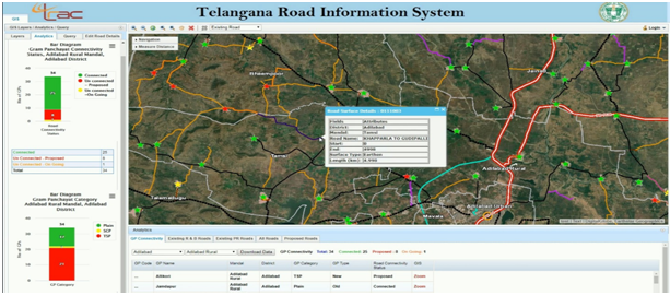
All the Panchayat Raj roads were identified and extracted from high resolution satellite data, Cartosat - 1. The surface type details were linked to the road information and Geodatabase was hosted in the NRSC Bhuvan Portal webserver, which is of immense use to the panchayatraj department.

Sponsored by National Remote Sensing Centre, ISRO, Department of Space, and Government of India.
Rural Development depends on assessment of the required amenities and management of the existing ones, such as Roads,Schools,Hospitals and Sanitation etc, there is an urgent need of spatial inventory of the existing assets before investing for new assets as most of the database on assets doesn’t have spatial location. The objective of this project is asset mapping, activity planning, and implementation and monitoring of development activities at Gram panchayats level.
Bhuvan Panchayat Mobile App by NRSC/ISRO would be used in this project. This App is well integrated with web portal, it supports the services of mobile mapping and in web portal supports visualization and editing A pilot study was taken up by TRAC,in Veliminedu and Pittampally Grampanchayats of Chityal Mandal, a total of 244 assets were captured, which includes assets such as, Governance, Productive, Human resources, Natural resources and Civic Amenities. The spatial location, attribute information and photograph of each asset, is processed for Geodatabase, which is further used for spatial analysis to support the efficiency of asset management. It is understood that Asset Mapping helps in planning, transparency and making quick decisions to execute the projects at Grampanchayats level. As the work is appreciated at national level it is planned to extend the Asset mapping for Mahabubnagar district,later on entire State.

- The objective of the project is to bring the PR road network of Telangana State on GIS platform with necessary attributed information along with other layers.
- Mapping the road surface details with attribute information.
- Mapping of Gram Panchayat wise connectivity.
- Development of web interface along with Mobile application for Geo-tagging the photos in the web interface.
- To create a comprehensive Road network GIS database for the state In addition to PR Road network, R&B and NHAI Road network has also been brought on to GIS platform.
- GIS database created based on the records of the concerned departments has been updated and validated using HR Satellite Imagery.
- All the 12,751 Gram Panchayat Headquarters (GPs) in the state along with their habitations have been inventoried, the status of road connectivity to the GP Headquarters have been mapped and all weather road connectivity is proposed to the unconnected GPs using HR Satellite Images in conjunction with field data.
- A web based GIS Portal with tools for statistical analysis and spatial querying has been developed for decision making and planning the developmental activities by the department.