Land use & Ecology
Objective: Urban Local bodies are under serious threat of encroachment and pollution due to rapid growing rate of urbanization and industrialisation. The main objective is to identify the lakes vulnerable to encroachment and feeder channels under threats for better planning for action against encroachment of lakes/ponds, assist for alternative way for sewage diversion, planning for conservation to improve the overall lake environment and its surroundings for enriched biodiversity. The data can be shared by all the implementing agencies to work in coordinated manner to draw suitable action plan for the lakes/ponds which are under serious threats.
Data set:Merged Imagery of Cartosat-1 PAN 2.5 m+ LISS IV MX 5.8 m.
Output: Creating a vulnerability index of the lakes Map of encroachment area of lakes/ ponds. Identification of changes in the feeder channels blocking the inflow into the lakes. Scale:1:5K
Sponsored by National Remote Sensing Centre, ISRO, Department of Space, and Government of India.
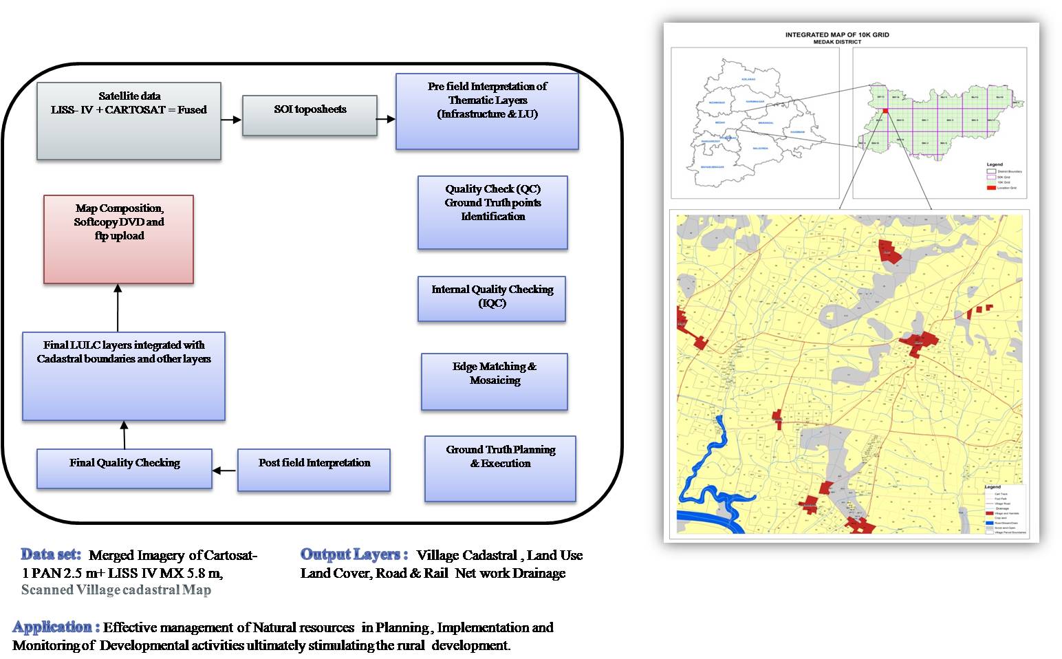
TRAC has contributed in spatial depiction of reliable Land and Water resources information at 1:10,000 scale to support effective Management of Natural Resources in Planning, Implementation and Monitoring of Developmental activities.
For the first time in Telangana state Landuse/Land Cover mapping at 1:10,000 scale is completed for entire Telangana State, which would be of great use for all the developmental activities of the State.
Input:
Output:
National Remote Sensing Centre has communicated to TGRAC, about the following three projects being taken up at national level and for Telangana State TRAC would sign the MoU, with NRSC.
Waste Land MappingA detailed satellite data interpretation for extraction of all the wastelands of the state would be carried out.
Land Use Land CoverLand use Land cover mapping at 1:50,000 scale is being carried out at an interval of 5 years at national level 2015-16, Land Use Land Cover Mapping would be carried out and would be compared with 2010-2011, 2005-06 Land Use Land Cover mapping for knowing the dynamic land use changes taking place over a period of time.
Land Degradation MappingLand degradation mapping of the Telangana State would be taken up for 2015-2016. The impact on biophysical environment through various human induced factors would be studied in this project.
- Updating of land use/land cover vector of 2011-12 using orthorectified three season Resourcesat LISS III data of 2015 – 16 and LISS IV and Carto 2.5 merged Satellite data of 2020-21 using Bhuvan Web Geo-portal or otherwise.
- Identification and depiction of areas with major changes to arrive at land use/land cover changes from 2005-06 to 2011-12 to 2015-16 to 2020-21
- Preparation of report containing category-wise change statistics
- Spatial distribution of change and other ancillary information like ground truth point file along with ground photos etc.
- Seamless land use/land cover layer of 2020-21 for the State and each of the districts in geodatabase format (.mdb and .gdb) along with statistics.
Regional Remote Sensing Centre (RRSC), National Remote Sensing Centre (NRSC), ISRO, Dept. of Space, Govt. of India
Sponsored by National Remote Sensing Centre, ISRO, Department of Space, and Government of India.
TRAC has contributed to the spatial depiction of reliable Land and Water resources information at 1:10,000 scale to support effective Management of Natural Resources in Planning, Implementation and Monitoring of Developmental activities.
10,250 village cadastral maps have been digitized on high priority and submitted to ISRO/NRSC. The data would be hosted in Bhuvan Panchayat for development and monitoring of decentralized planning.
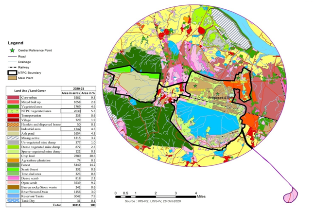
Sponsored by National Thermal Power Corporation Limited (NTPC), Ramagundam.
NTPC Ramagundam got the clearance from Ministry of Environment and Forests for setting up of Telangana Phase-I (2*800 MW) project. The clearance is with a condition that Landuse/Landcover status must be generated using the latest authenticated satellite imagery and should be submitted on annual basis.
NTPC Ramagundam has approached TGRAC in this regard, as per the requirements of the Ministry, a proposal to interpret and analyse annually the multi date satellite imagery, for monitoring the Landuse/Landcover for eight years is submitted.
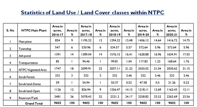
- To interpret the spatial distribution of LU/LC features and analyze the extent of temporal changes on 1:10,000 scale
- Identification and depiction of areas with major changes between 2016-17 and 2023-24
- Preparation of report containing category-wise change statistics; spatial distribution of change and other ancillary information like ground truth point file along with ground photos
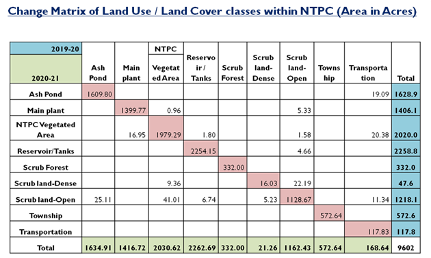
- Seamless land use/land cover layer of 2016-17 and 2023-24 along with statistics and cross-matrix.
- Land use/land cover change map between 2016-17 and 2023-24 along with change statistics and cross-matrix table.
- Preparation of report containing category-wise change statistics; spatial distribution of change and other ancillary information like ground truth point file along with ground photos
NTPC Ltd. Ramagundam STPP, Telangana