Agriculture & Soil
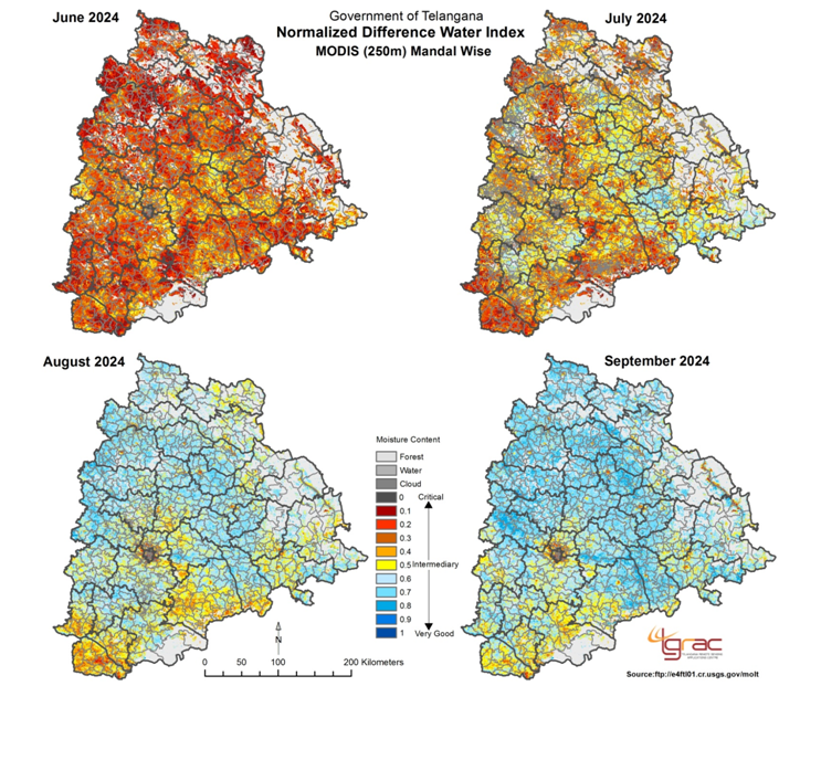
Telangana Remote Sensing Applications Centre (TGRAC) has established a protocol Integrated Seasonal Condition Monitoring System (ISMS) based on developed methodology of NRSC/MNCFC. The different activities carried out through ISMS commence with acquisition of MODIS (250m) and AWiFS (56m) satellite data. The satellite data being processed and NDVI and NDWI indices are developed. Based on these indices deviation with respect to normal year (2013), VCI calculation and Mandal wise Statistics are derived. The agricultural situation is assessed incorporating Rainfall deviation, Command and non command areas and dry spell and information followed Weekly sowing progress and Reservoir levels. The agricultural situation is classified in three to four categories i.e. Normal, Watch, Alert for June to August and Normal, Mild, Moderate and Severe for September to October. This output is verified through ground truth, additionally in context of the state specific drought declaration criteria.
Objectives:- Concurrent monitoring of seasonal conditions using remote sensing, extensive weather network data and continuous ground truth.
- Develop an early warning (monitoring) of drought using suite of indicators, which will help to increase drought preparedness, and identify and implement appropriate Disaster Risk Reduction (DRR) measures.
- Early Warning to the Districts/Mandals
The study is carried Mandal wise for entire Telangana.
Duration of the Study:June to November (Kharif Season, every year)
Output:Fortnightly report submitted to Commissioner, Disaster Management, Revenue department, Govt. of Telangana.
Data Sets:- MODIS (250m, 16 day composite) and Resourcesat-2 AWiFS data for entire Telangana.
- MODIS Data, ftp://e4ftl01.cr.usgs.gov/molt/ Season And Crop Coverage Report, Kharif - 2013, http://agrisnet.tg.nic.in Water Levels and Water Release Data, http://cadarsms.cgg.gov.in

- Technique development for sugarcane, groundnut, maize, sorghum and cotton crops discrimination, acreage and production forecast using multi-temporal AWiFS and Risat SAR data and validation of rice biomass in selected places.
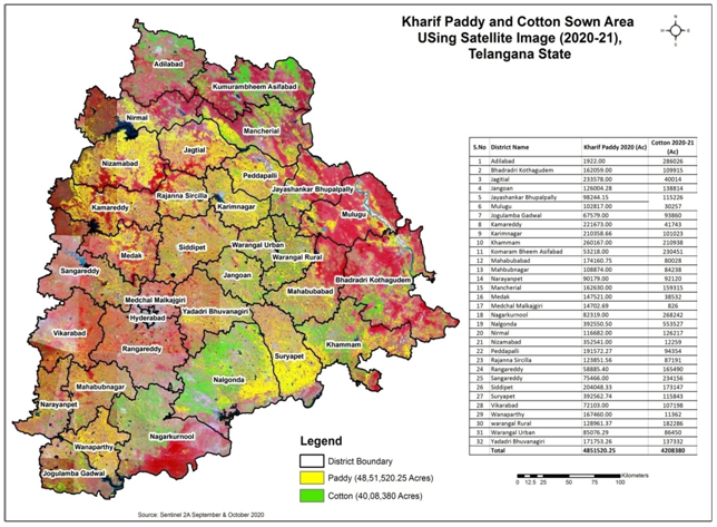
- Kharif Rice: Acreage estimation of Kharif rice in major Rice growing districts of Telangana for National / State Forecast -NSF
- Kharif Cotton: Acreage estimation of Cotton in major cotton growing districts of Telangana for State/ District forecast- SDF
- Rabi Rice: Acreage estimation of Rabi Rice in districts of Telangana for National State Forecast and State District Forecast-NSF & SDF
July to May (2023-2024)
Deliverables:Acerage and Production at District level.
Data Sets:- Multidate SAR/Sentinal 2A & Landsat-8
Department of Agriculture & Farmers’ Welfare (Mahalanobis National crop Forecast Centre), Ministry of Agriculture, Govt. of India


- Kharif Rice: Acreage estimation of Kharif rice in major Rice growing districts of Telangana for State Forecast / District forecast.
- Kharif Cotton: Acreage estimation of Cotton in major cotton growing districts of Telangana for State/ District forecast
- Rabi Rice: Acreage estimation of Rabi Rice in districts of Telangana for State Forecast and State District Forecast
July to May (2024-2025)
Deliverables:Crop Acerage Estimation at District level.
Data Sets:- Sentinal 2A & Landsat-8


Accurate information on nature, extent and potential of soil resources is essential for optimal utilization of the resource for sustainable development. Study of soil resources at large scale mapping using Satellite Imagery has proved to be quite useful as it reduces time and man power required when compared to gathering information through ground surveys.
Objectives:- Preparation of soil resource maps of Six districts of Telangana namely Warangal Rural, Warangal Urban, Jangoan, Mahabubabad, Siddipet and Yadadri Bhuvanagiri Districts at 1:10000 Scale using IRS LISS- IV satellite data, soil profile studies, and analysis of soil samples.
- Creation of digital soil data base for the six districts in GIS environment.
- Methodology of soil resource mapping involves the following steps:
- Step-1:Development of Legend.
- Step-2:Pre-field Interpretation for delineation of soil mapping units by using Lithology,Physiography, Slope and Land Use/Land Cover information and development of pre field legend. Selection of sample sites.
- Step-3:Ground Truth collection including profile studies and collection of soil samples.
- Step-4:Soil sample analysis.
- Step-5:Finalization of classification, Post field Interpretation and Map finalization.
- Formulation of Soil Mapping Unit through Six Level Study as per SLUSI Standards.
- Level-1: Landscape
- Level-2: Physiographic
- Level-3: Slope
- Level-4: Land Use
- Level-5: Association of Soil Series
- Level-6: Soil Phases:Each mapping unit is subdivided based on image character to represent a set of soil characteristics like Soil depth and Surface texture, Erosion, Slope and stoniness with in Soil Series and Associations of Soil Series. Details of soil characteristics and their classes required for establishing Soil Phases are as follows:
- Soil data base creation of Six Districts namely Warangal Rural, Warangal Urban, Jangoan, Mahabubabad, Siddipet and Yadadri Bhuvanagiri Districts at 1:10000 Scale.
- Land Capability, Land Irrigability and Crop Suitable maps at 1:10000 Scale
- Soil Survey Reports
Soil & Land Use Survey of India, Department of Agriculture & Farmers Welfare, INM, Government of India, IARI Buildings, PUSA, New Delhi